Changes to the design are set out by Southern Water in 25 separate Design Refinement Documents which are available on their website www.HampshireWTWRP.co.uk
The map below shows the locations of 25 planned infrastructure changes which are the subject of this consultation:
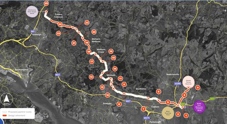
Feed back is requested on the design refinements in the SW Feedback Form Question 2a & b. The six changes applicable to the Havant area, numbered in this detail from the map, are covered in the six following sections below.
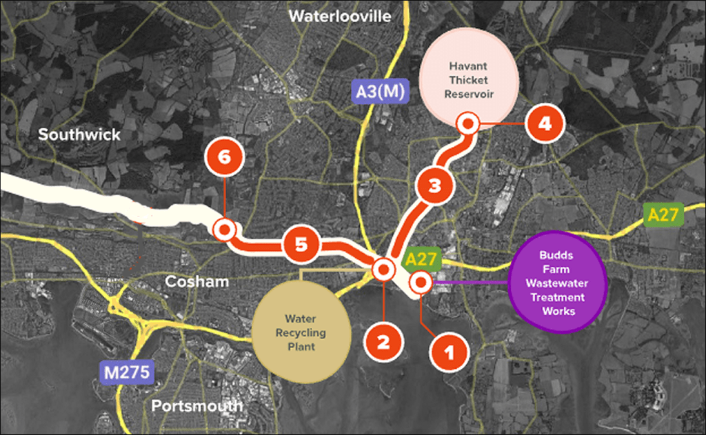
The detail behind the six points on this local view of the map are covered in the sections below. For each section, the key changes are described below, along with comments on concerns that you may want to consider.
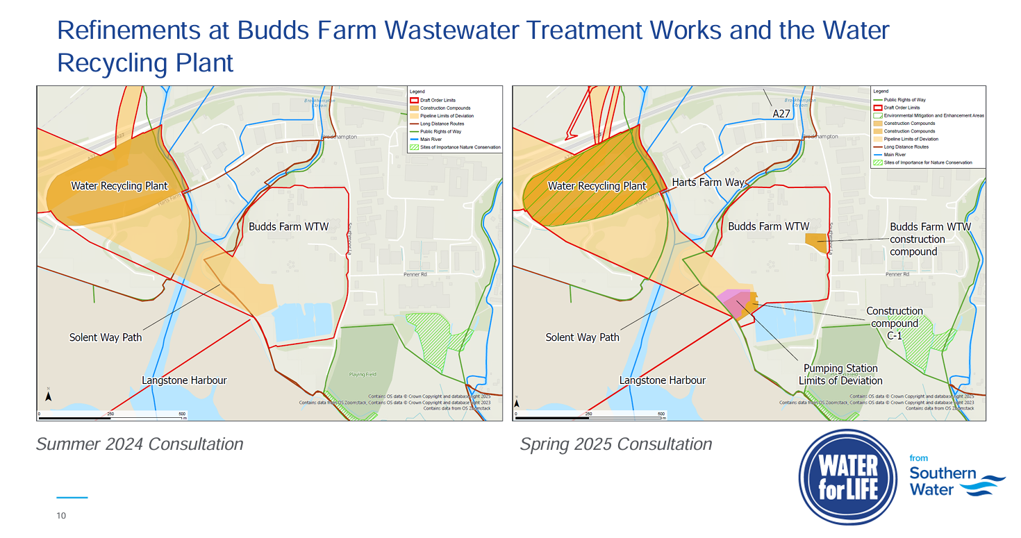
Design Refinement 1 – Budds Farm area
To open the Design Refinement document in a separate browser tab, click on the heading above.
- This design change proposes an additional pumping station to transfer treated final effluent from the Budds Farm sewage works to the higher ground on which the Water Recycling Plant (WRP) is located at the Broadmarsh Coastal Park (a former landfill site).
- The dimensions for the proposed new pumping station size are; Height 3.3m, Length 12m, Width 7m.
- Two new construction compounds are also planned.
Concerns to consider – Refinement 1
1 – The addition of a pumping station means that final effluent (contaminated water) will be pumped under pressure from Budds Farm to the effluent recycling plant. The pipe passes below the tidal section of the Hermitage Stream. Any burst or leak will pose a significant risk to Langstone Harbour. The risk is increased if the water is pumped, as the volume released in a burst would be greater. The risks are not considered in the water quality report assessment.
2 – The pumping station will be located at Budds Farm sewage works on land reclaimed from the sea by historic landfilling. There is a significant risk that the site will be contaminated.
3 – Construction of the pumping station and associated pipelines pose a risk of mobilising silt and even leachate which could be discharged into the stream or harbour SPA/SAC.
4 – There is no information on where the washouts will be for the 2 new pipelines which will carry Budds Farm final effluent and the WRP reject water. Sediment build up in these pipes is likely to be an issue due to the nature of the contaminated liquids they will carry. Use of the washouts to clear the pipelines could result in discharge of contaminated liquid and sediment to the stream and/or harbour.
5 – Tunnelling below the tidal section of the Hermitage Stream could cause noise, vibration and mobilisation of sediment, in an area of the harbour which is important for birds (SPA). It could also impact other species including fish within the SAC/ SSSI.
6 – The construction site and additional 2 construction compounds will be very close to the harbour so there could be potential impacts from construction work on the harbour, birds and other species using this part of the harbour to feed, drink and roost. The work would be taking place at the same time as the construction of the WRP close by and could result in cumulative and combined impacts on birds, driving them away from this part of the harbour SPA.
7 – The new infrastructure at Budds Farm WWTW will be visible from the Solent Way long distance footpath.
8 – Important to minimise vegetation loss and retain the existing embankment
9 – Additional energy and carbon impact as final effluent now to be pumped to the Water Recycling Plant at Broadmarsh
10 – Important to have a robust Construction Environment Management Plan
Design Refinement 2 – Broadmarsh & Water Recycling Plant site
To open the Design Refinement document in a separate browser tab, click on the heading above.
- Southern Water propose to increase the height of the main Water Recycling Plant building by 1.5m to terminate 14.5m above the landfill, making the already unacceptable landscape impact even greater. Tree screening will not be practical and the industrial structure will be visible from all around Langstone Harbour, Portsdown Hill and Old Bedhampton.
- A new phosphate treatment plant is proposed (no detail provided), Southern Water are currently assuming that this can be accommodated within the existing WRP footprint.
- Environmental mitigation areas are said to have been added but it is not clear where this is, no maps are provided, but said to include landscaping to screen views of the WRP, presumably this refers to areas for tree planting.
Note: Southern Water have confirmed that the Development Consent Order application will be in outline only, indicating the scale of the main WRP building only (maximum height and area). If approved for outline consent by the Secretary of State a detailed application for the WRP would then be submitted to the Local Planning Authority (HBC). Who can only determine if the detailed design complies with the design principles already approved in the outline consent.
Concerns to consider – Refinement 2
1 – Significant visual impact of the higher WRP industrial building on the open coastal landscape, especially views from Langstone Harbour and Portsdown Hill. Southern Water confirm in their text that the increase in height “will inevitably result in the building becoming more prominent in the landscape”.
2 – In addition to the main plant building there will be many other tall tanks and silos to provide storage for final effluent and chemicals at the site which will urbanise the northern side of Langstone Harbour further.
3 – A taller building is likely to require deeper piles, adding to concerns about new pathways being created for contaminated leachate to drain into the chalk aquifer and harbour waters, which are hydraulically connected.
4 – Additional chemical storage likely to be needed for the new phosphate treatment process.
5 – Additional cost of the phosphate treatment plant to construct and operate daily.
6 – Additional energy and carbon needed to build and operate the extra phosphate dosing plant. Adding to an already extremely high energy and carbon footprint for the project
7 – Tree planting is not practical to fully screen all of the plant given its elevated position on top of a landfill mound which is already more than 13m above sea level. Any screening planted will be slow to grow on the landfill in this exposed coastal location.
8 – The landfill contains toxic chemicals and is still producing landfill gas. It is highly likely that trees will die as they start to reach the substantial height needed for screening, as their roots reach deeper and oxygen is displaced from the soil by landfill gas (carbon dioxide and methane).
9 – The higher building will be lit at night increasing visibility from across Langstone Harbour.
10 – Essential lighting at night will be spread across the elevated WRP site and this will add to the adverse visual impact from around the harbour after dark.
11 – Lighting will also have adverse impacts on the night time ecology at the Broadmarsh Coastal Park, most notably on bats and their prey.
12 – The proposed green roof is described as an ‘on site habitat enhancement’ Yet there is already grassland at the site. Is it realistic to expect a green roof to flourish in this exposed, windy, raised, coastal location?
13 – No information is provided on how or where the loss of existing habitat at Broadmarsh will be mitigated for?
15 – Wader & Brent Goose Strategy areas are impacted by the construction of the WRP at Broadmarsh.
16 – Development of the WRP on the Broadmarsh landfill has too many adverse effects, including significant risks to harbour water quality and adverse impacts on the coastal landscape and views. An alternative site for the WRP should be identified by Southern Water.
17 – The previous assessment of alternative sites for the WRP was inadequate and not robust.
18 – Would it be better to use the roof of the building for Solar PV panels, especially given the plant’s very high energy & carbon impact, rather than turf?
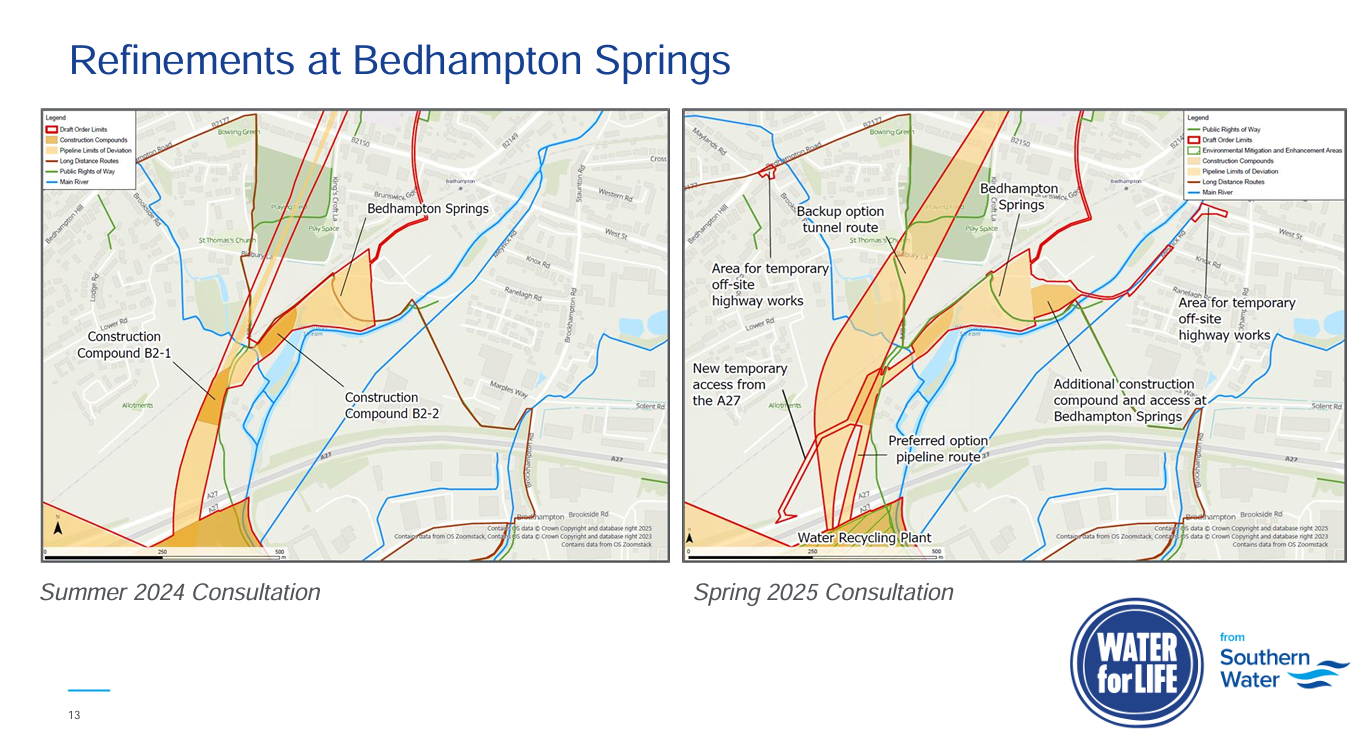
Design Refinement 3 – Bedhampton area through Leigh Park to reservoir
To open the Design Refinement document in a separate browser tab, click on the heading above.
- Order limits (project boundary) have been extended for parts of the scheme at Bedhampton Springs site, to include an additional access road and an additional construction compound. The Order Limit is the maximum expected extent of the land the Project would be delivered within. It includes the area required for above ground plant, pipelines, access routes and temporary work areas required for construction. See red lines on map, above.
- The width of the Order Limits have been reduced in places along parts of the tunnel route as Southern Water say they don’t have to consider the area of potential settlement from tunnelling.
- A new temporary road is proposed from the slip road off the A27 to Mill Lane (Old Bedhampton) for abnormal and heavy loads to use to prevent damage to the old railway bridge.
- Temporary changes are proposed to the Brookside Road/ Bedhampton Road junction to accommodate construction traffic, this includes modifications to the junction geometry and traffic islands.
- Meyrick Road and West Street junction now included where they may need to implement temporary parking restrictions to ensure construction vehicles can use the junction safely.
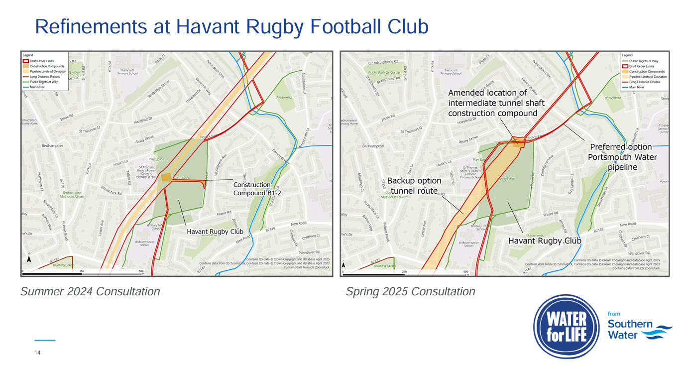
- Rugby club compound and intermediate shaft location have been moved a bit (see SW map, below.)
- Middle Park Way will now have 1 not 2 compounds.
- Env mitigation/ enhancement area proposed at Staunton Country Park fields
Concerns to consider – Refinement 3
1 – Still not clear where the tunnel shafts will be between the Water Recycling Plant and West Street, this information is needed to be able to judge the impact on local roads, residents, public open space and sensitive parts of the conservation area. Are the shafts located within the compound areas shown on Figure 7?
2 – Support the proposal for a new temporary road from the slip road off the A27 to Mill Lane (Old Bedhampton) for abnormal loads to prevent damage to old railway bridge. This is positive as this would keep these heavy loads out of Old Bedhampton. Do not support construction traffic being routed through Old Bedhampton and the conservation area to reach Mill Lane. If the new temporary access route from the A27 slip road is good enough for heavy loads why could it not be used for all construction traffic to protect the Old Bedhampton conservation/ residential area from noise, vibration and traffic chaos, as the lanes are very narrow? Approval will be required from both National Highways and Hampshire County Council Highways.
3 – If abnormal and heavy loads will use the new temporary access from the A27 slip road why does the Brookside Road/ Bedhampton junction need to be upgraded? Any work at this junction will cause significant traffic congestion and difficulties for residents needing to access Old Bedhampton. The alternative access route to Old Bedhampton at Kingscroft Lane is very narrow with steep banks and tree lined, it would not be safe for even the temporary diversion of traffic.
4 – Multiple housing developments are planned in the Bedhampton area, what will be the cumulative impact on traffic flows and how is this being assessed? This is a particular concern at Meyrick Road.
5 – Changes to the shaft and compound location at the Havant Rugby Club are shown on the map below. These are an improvement but there will still be a significant impact on the Rugby Club, St. Thomas Moore school and the local community, with loss of public open space and disturbance for a significant time period.
6 – The impact on the mature tree line at Middle Park Way for the construction access must be minimised and avoid all mature trees. There is no detailed map for this area. More detail needs to be provided on the area/ trees impacted and the proposed mitigation area.
7 – Concern about an additional construction compound at Bedhampton springs and the additional traffic it will generate, with the Meyrick Road/ West Street area already being very congested, and set to get worse with the likely construction of more than 200 new homes.
8 – If the pipeline is routed parallel with the railway to avoid veteran trees will this have any impact on the footpath?
9 – There will be a high level of disturbance to residents living close to the intermediate tunnel shaft B2-2 by Hooks Farm Way, would these residents be offered compensation or alternative accommodation for the duration of the works?
Refinements at Havant Rugby Club
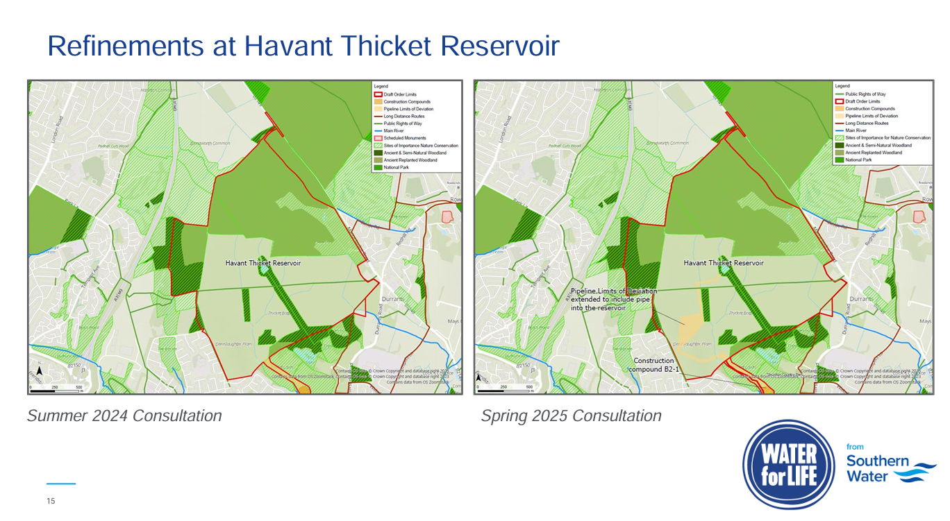
Design Refinement 4 – Havant Thicket Reservoir
To open the Design Refinement document in a separate browser tab, click on the heading above.
Developed a route for the connection point to the Portsmouth Water pipeline.
Revised the position of the inlet pipe so that it now extends further into the reservoir bowl.
Concerns to consider – Refinement 4
1 – The extension of the reservoir inlet pipe further into the reservoir means that the water quality modelling is already out of date, as that was based on the previous shorter inlet pipeline discharge point.
Refinements at Havant Thicket Reservoir
Design Refinement 5 – Pipeline Section D – Broadmarsh to Portsdown Hill (London Road)
To open the Design Refinement document in a separate browser tab, click on the heading above.
- Some changes to the tunnel routing
- West end of route widened
- East end of route – width reduced
- Location of intermediate tunnel shaft and compound south of Portsdown Hill Road and west of Gillman Road
- Removed potential tunnel settlement areas from order limit area
Concerns to consider – Refinement 5
1 – Traffic disruption needs to be considered and how it can be minimised on Portsdown Hill Road as an intermediate shaft is now proposed where there was previously just a compound. Construction work around a shaft takes place over an extended period.
2 – The west end of the Section D tunnel may now pass below 2 Sites of Importance for Nature Conservation, where there are steep slopes.
Design Refinement 6 – Portsdown Hill Break Pressure Tank and Pumping Station (NW of the old A3 London Road and north of Portsdown Hill Road)
To open the Design Refinement document in a separate browser tab, click on the heading above.
- Both a western and northern route is now included (i.e. 2 potential routes, which one will be used will be determined by pre-construction surveys)
- Grey shaded area for infrastructure footprint is now bigger
- Area increased to allow for security fencing
- Plan to excavate deeper to mitigate the increase to the footprint to help reduce the visual impact
- Amended area impacted by works to avoid protected species
- Environmental mitigation area shown to the west
Concerns to consider – Refinement 6
1 – There is significant protected species activity in this area, great care will need to be taken to avoid impacts.
2 – Impact on hedgerows need to be minimised to maintain habitat connectivity.
3 – Visual impact of an industrial building in a rural area on top of Portsdown Hill.
4 – The development permanently extends the urban area further along the top of Portsdown Hill into what was a rural landscape.
The other 19 Design Refinements
The other 19 Southern Water refinement documents cover changes to locations from Portsdown Hill to Otterbourne, including river crossings. These are also available on the SW website at www.HampshireWTWRP.co.uk
